Tuesday, November 21, 2006

Gulugod Baboy


How to go
First you need to ride a Batagas City Pier Bound Bus.. the fare is around 146 pesos, tell the conductor you are going to Anilao. Form Batangas City you will catch a jeep bound to Mabini/Anilao the fare is around 23.50 pesos (just tell the driver that you are going to Anilao). Again you'll find yourself in a terminal of jeepneys.. just tell them you are going to Philpan resort the fare is around 14.00 pesos. from philpan resort you will see a cemented path going up. You can either start the hike or eat first at nearby stores(i recommend the lomihan just beside philpan resort)

Tips
You must consider packing lightly for there will be steep portion throughout the hike, water source is available near the summit just look for a shanty near the campsite, and wear protective clothing from the sun.

Monday, May 29, 2006

Wawa Dam


How to go

There are three ways to go there from Quezon City by means of public jeepney.First is the route of Philcoa-Montalban jeepney, just look for the jeep going to Montalban in front of Jollibee. Fare is 26 pesos as of May 2006. As you arrive in Montalban, look and ride a jeep going to Wawa and don't forget to pay 7.50 pesos as your fare.Second route is by means of Montalban-Cubao jeepney near or in front of Sogo Hotel. As you arrive in Montalban, look and ride a jeep going to Wawa .The last route is a jeep in Litex-Montalban. Fare is less than 17 pesos and just tell the driver to unload you in loading area going to Wawa. From here look and ride a jeep going to wawa.

From Wawa you can either go to straight to the dam, Its about a 10 minute walk from the drop-off point to the dam. You can also ask assistance from the barangay who are pretty much willing to assist and guide you to the trip ( I just don't know if there is money involved).

Wednesday, May 10, 2006

CORREGIDOR ISLAND


Corregidor island is just a few kilometers from Manila (48 Kilometers to be exact), Its is the first line of defense of Manila during the war. This island fortress stands as a memorial for the courage, valor, and heroism of its Filipino and American defenders who bravely held their ground against the overwhelming number of invading Japanese forces during World War II. Also known as "the Rock," it was a key bastion of the Allies during the war. Today Corregidor serves as one of the tourist spot of this country. Our trip to corregidor is quite exciting, due to the fact that it was our first time to go there. Plus the fact that it is both historical and a beautiful place. Made us more eager to go to the place where history is written everywhere, a place once become a graveyard for hundreds of soldiers fighting for our freedom.

When and How to Go

You can go to Corregidor Island all year round, just make sure it is not storming cause you have to ride a boat to go there. But if you are not familiar with the place it is better to avail of the Corregidor Day tour packages at CCP. The package is inclusive of Lunch, Boat Fare and the Tranvia ride with tour guide. But you have to pay extra if you want to watch the Malinta Tunnel Lights and Sounds Show. It is also allowed to bring food to the trip and I have to say that the food there is expensive, imagine a can of soda for 90 pesos. So if you can bring food might as well do so.

Friday, May 05, 2006

Malibiclibic Falls


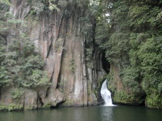
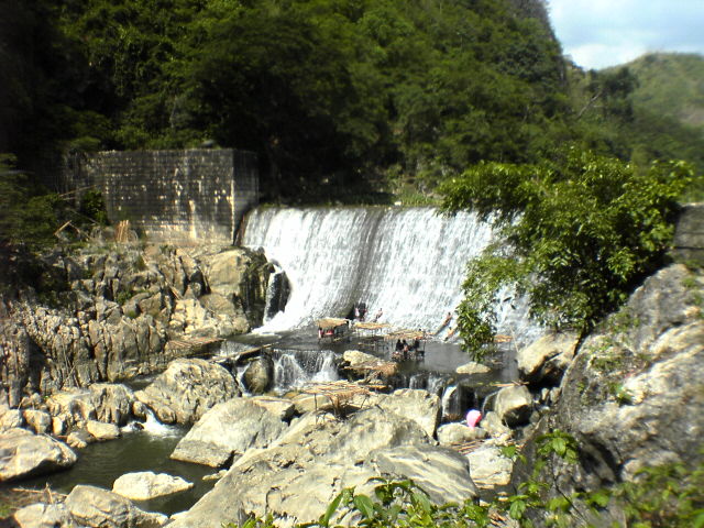
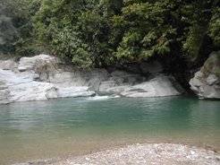
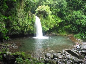
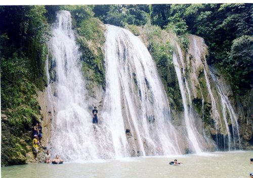
Malibiclibic falls is not a popular hiking destination. Some people can’t even believe that there is a waterfall in Cavite. As what I have researched there is two waterfalls in Cavite one is the Balite Falls and the Malibiclibic. Malibiclibic falls has a large catch basin and is ideal for swimming, for those who know how to swim. A local there tell us that it is 10 to 15 feet deep. The water sometimes tends to get musky when it rain. It also has a nice place to camp and it can accommodate 5 to 7 tents, depends on the sizes of the tents.
You can also witness monkeys playing on top of the trees if you are lucky.
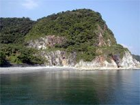
How to Go and When


Malibiclibic falls is located at Brgy. Lumipa, Aguinalo, Cavite. You can go there by the Baclaran – Alfonso bus or the Baclaran - Naic bus.

From Baclaran take the bus going to Alfonso Cavite, It will pass by Bacoor, Imus, Dasma, Silang, Tagaytay etc.. then the last stop will be Alfonso.
From Alfonso you will then ride a jeep going to Aguinaldo. From Aguinaldo you will then ride a tricycle going to Brgy. Lumipa. From there you can ask for directions from the locals. It is better to ask at the brgy officials. From the brgy hall it is a 20 minute walk more or less to the campsite.

You can also take the bus or FX going to Naic, Cavite. From Naic you can then catch a jeep going to Aguinaldo Bayan. It will pass by brgy Lumipa. And if you know your directions you can go down near the trail to the campsite.

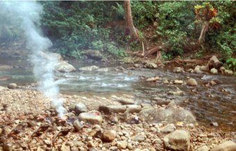
It is better to go during summer, the water tends to get musky during the rainy season and it makes the trail muddy and the rocks slippery.


(Aguinaldo is not the Aguinaldo Highway, it is a town)

Wednesday, April 05, 2006

Tukuran River, Puerto Galera


If you plan to go to Puerto Galera, I suggest that you insert this place in your itinerary. A 45min jeepney ride from town of Puerto Galera to the drop off. A real fun and hiking that you need to pass the four (4) rivers and see the natural made wonders of stream rivers. This also gives you the chance to cross the half kilometer infamous hanging-bridge. If you're a nature lover this is a must activity for you. Last January 2006 there is a new water fall flowing near Tukuran, residents tell me that after the storm the water made a new path way flow, thus creating this new waterfall.

WHEN AND HOW TO GO

Going to Tukuran River, Puerto Galera is simple and has many ways. You can either contact a travel agency or go to there with only the guts and some advice from what you are reading now.
If you plan to go there it is nice to go there during the off peak season specially on weekdays, the place is very crowded during the summer and it tends to make the prices go off the roof.
To go there first catch a bus going to Batangas City Pier, Upon arriving the port you have to get a ticket for a boat ride going to White Beach (suggested boat M.V. Bernie ) don’t worry there are plenty boats to choose from, just be sure it is going to White beach. You will then dock at White Beach where you can do your canvassing for rooms/ and accommodations. The boat trip is quite a ride and it has many schedule to choose from but it is better that you get there early by riding the bus early. From Puerto you can either hire a jeepney or tricycle to take you to tukuran. From the jump-off point you can either ride a carabao that tows a cart or you can walk and pass the rivers by foot. The bus ride from Buendia to Batangas Pier will be about 1 ½ to 2 hours which is pretty much the same for the boat ride, so it will cost you around 3 hours to get to White Beach Puerto Galera plus 45 minutes more to go to tukuran.

White Beach, Puerto Galera, Mindoro


White Beach is one of the many beaches of Puerto Galera, in Oriental Mindoro. With hotels just right beside the beaches, not to mention pretty affordable accommodation packages and a variety of resort/hotel to choose from, you can very well save a little money and spend it on other things. The beach is well maintained, there is a spot for people to swim, a spot for people to jet ski and other water activities, and there are many people offering snorkeling for a fee (be sure to try to bargain you can get it really cheap if you know how). Plus you can buy friendship bond for about 3 for 10 pesos (January 2006) so the pasalubong things will not be that expensive for those who are tight in budget. The fun doesn’t stop here, at the afternoon you can witness a wonderful sunset or just wait for the darkness to take place for a more exciting nightlife at Puerto Galera.

WHEN AND HOW TO GO


Going to White Beach, Puerto Galera is simple and has many ways. You can either contact a travel agency or go to there with only the guts and some advice from what you are reading now.
If you plan to go there it is nice to go there during the off peak season specially on weekdays, the place is very crowded during the summer and it tends to make the prices go off the roof.
To go there first catch a bus going to Batangas City Pier, Upon arriving the port you have to get a ticket for a boat ride going to White Beach (suggested boat M.V. Bernie ) don’t worry there are plenty boats to choose from, just be sure it is going to White beach. You will then dock at White Beach where you can do your canvassing for rooms/ and accommodations. The boat trip is quite a ride and it has many schedule to choose from but it is better that you get there early by riding the bus early. The bus ride from Buendia to Batangas Pier will be about 1 ½ to 2 hours which is pretty much the same for the boat ride, so it will cost you around 3 hours to get to White Beach Puerto Galera.

Monday, April 03, 2006

Mt. Famy (Romelo), Siniloan Laguna


Mt. Famy is located at Siniloan Laguna, It is famous for its waterfalls mainly the Buruwisan falls, It is said that Mt. Famy have 5 waterfalls but I have only been to two of those five. It is also suitable for swimming due to its many water basins where the water flows. It also has a potable water source not far from the campsite not to mention sari-sari stores everywhere. In the summer the water flowing beside the campsite decreases and In the rainy season it tends to get very slippery and the term that you will kiss the earth is true (based on experience) but you can put it to fun by counting the person who has the most slip ups.


WHEN AND HOW TO GO

2 routes are available going to Mt. Famy, you can either go to the Tanay route where you will pass the scenic town of Rizal and laguna de bay, or you can ride a bus going to Sta Cruz Laguna and from there you can take a jeepney going to Siniloan, where it will pass towns like Paete and Pagsanjan. It will both end up at the terminal of Siniloan and from there you will take a tricycle going to Mt. Famy. It will be a few meters walk from the highway to the jump-off point where you have to register. From there you can either hire a horse to carry your stuffs or carry it yourself. It is advisable to go during the summer for its gets very slippery during the rain. (come to think of it we always go there during the rainy season) Well Rain means water, and it means more water to play around.

Taytay Falls, Majayjay Laguna


Taytay falls (Imelda falls) is located at Majayjay Laguna. It has become a habit for me to go to taytay falls at least once a year. I see it as a good place to loosen up and enjoy the fruits of nature without spending a lot. Majayjay is only 2 to 3 hours away from Manila and its passable by the Magdalena route or the Lucban route. If you want to eat pansit habhab and visit the town which is known for their pahiyas festival, I suggest you take the Lucban route. But if you want to pass by liliw Laguna and look for nice shoes well you can take the faster Magdalena route. Taytay falls is ideal for swimming due to its large catch basin and it has many smaller basins near the waterfalls for kids and for those who don’t want to leave their things unattended. In my experience that I been here at Taytay falls, never had I encounter nor have I experienced being robbed, mugged or any thing like that. It is very peaceful and the folks who live here are very nice. But please let’s keep this place clean.

HOW AND WHEN TO GO THERE

Catch a JAM or TRITAN BUS with the STA CRUZ sign at Buendia, You will get down at Sta Cruz and catch a jeep ride going to the public market. At the market you will have to go to the terminal of jeepneys going to majayjay, when you reach majayjay you will go down at the terminal going to Imelda falls or taytay falls it’s just the same falls. The jeep are going straight up to the registration point so trekking will only take you around 15 minutes to reach the campsite. It is okay to go to Majayjay all year round and if you have a car you can park it up there for a cost of 40 pesos overnite, the registration fee is 20 per person, a small price to pay.

Daraitan Rizal, Daraitan River


Daraitan is one of the places you have to go in Tanay Rizal, aside from its river system it has peaks to conquer and cave to explore. It is advisable to go here during the summer for sometimes in the rainy season the water of the river overflows that makes it impossible for jeepneys to cross. Hurray for the banceros… for it will only cost you 5 pesos to cross the river riding a very thin banca that accommodates 5 to 6 persons including their backpacks. Just be careful cause the river sometimes flows very strong (reminds you of the movie river wild). Well from there you can the go to the barangay hall to register that will cost you around 5 to 10 pesos from there it’s a walk in the park.

HOW TO GET THERE
First go to Crossing at Shaw Blvd., catch a ride going to Tanay, Rizal. You will then get off at the Tanay’s public market which is also the terminal for rides going to location like Siniloan, Pililia and etc.. You will then catch a ride going to DARAITAN it will be easy to find this ride cause this jeepneys are bigger than most of the other jeeps and it has a bigger set of wheels, maybe for crossing the river. From here sometimes you have to wait until the jeepneys are full cause they won’t really go without a full jeepney and I think that they even let people ride the at roof. Depends on the condition of the river, sometimes the jeep will cross the river and from there you can start your hiking. Don’t forget to go first at the barangay hall to register it’s for your own safety. From there it’s a walk in a park, plus you can get potable water and it’s safe.

Daranak Falls


Daranak Falls nestles quietly at the foot of the Tanay mountains, preserved with the natural vegetation, complemented with beautiful waterfalls, ponds, and rivers cascading through elaborate tropical trees and plants. This 14-meter high falls is truly a refreshing site. A short walk over the top of Daranak are smaller, cascading streams known as Batlag Falls. It is located at Bgy. Tandang Kutyo in the town of Tanay. The place has been transformed into a public park/resort operated by the government. Camping at Daranak Falls is allowed but not for those who want to spend the whole night there, but to those who want to spend their night at this majestic place, you can settle at Batlag Falls the upper part of this place.

HOW TO GET THERE

First you have to go to Crossing at Shaw Blvd., From there catch a ride going to Tanay, Rizal. You will then get off at the town's public market, you can then ask people there how to catch a ride to Daranak Falls, in the rainy season the ride is sometimes not available due to lack of commuters, but you can either arrange a special trip with a tricycle or a motor turned into jeepney ( i forgot what its called ) and i think it will cost you aroud 200 - 300 pesos 2 way, and it will help, if you come in a group, so you can divide the travel expenses.

Liliw Laguna


Liliw is perhaps best known for its cold water spring resorts, native homemade sweets, Tuba and a sizeable shoe industry that rivals that of Marikina City. According to a story, Liliw got its name from a bird. It was said that Gat Tayaw and his followers decided to erect a bamboo pole and to name the town after the bird that would first alight at the top of the pole within four days. A crow, however, was the first bird to alight on the pole. A crow was considered bad and so Gat Tayaw and his men moved south and erected another bamboo pole. A beautiful bird alighted on the pole and sang, "Liw, Liw, Liw". Thus the town became Liliw.

Liliw is one of the highland towns forming the southern extremity of the province of Laguna. It is located 100 kilometers from Metro Manila via Sta. Cruz and 105 kilometers via San Pablo City. The municipality is bounded on the northeast by Magdalena (Laguna), on the northwest by Sta. Cruz, Laguna, on the west by Nagcarlan (Laguna), on the east by Majayjay (Laguna) and on the south by Dolores (Quezon).

HOW TO GET THERE
Going to Liliw Laguna is as easy as 123 if you have ever been to Imelda Falls, Majayjay Laguna. If your coming from Manila, just ride the Tritan or Jam transit busses that is going to Santa Cruz Laguna. from Sta Cruz Laguna you can then go to the public market to do your last minute grocery or straight to the terminal of Liliw. You can then ask the jeepney driver for directions or drive you straight to LILIW Resort.

Twin Falls, Cavinti Laguna


One of the light hiking destination for weekend hikers and beginners as well as non-hikers, the Twin Falls in Cavinti, Laguna is one beautiful destination to go to with a well-established trail that would entail only 1-hour of hike to reach the destination. Because of its relatively easily accessible destination point as well as a beautiful park located at its jump-off point, the place is ideal for introducing hiking to beginners as well as a place to bring non-hikers to enjoy nature without the hassle of strenuous hikes and inconvenient facilities. But for those who are scardy cat like me see to it that you go in numbers when you go on rainy season, for you might find yourselves alone in the campsite and its really really scary.. From the waterfalls, you can have a family picnic or swimming on the wide and deep basin at the base of the falls. It is truly more of an excursion or "walk in the park" than nature hiking.


WHEN AND HOW TO GO

Cavinti Twin Falls is open anytime of the year. The problem is that it lies within private properties so its existence relies on the discretion of the owner of the property. There are rumors that the place will be developed as a housing project which is the main concern regarding the preservation of the waterfalls. To go there, you can start by taking a bus towards Sta. Cruz, Laguna. From there, go to the public market where you can catch a jeepney ride towards Cavinti. Remember to verify with the driver if it would pass by the Japanese Botanical Garden. The trip alone is enjoyable in itself because it will show you scenic sights around Laguna particularly the man-made Kaliraya Lake which is a favorite tourist destination. The hike officially starts at the Japanese Botanical Garden, a project of the former First Lady Imelda Marcos, and a favorite picnic ground during weekends. Take time and explore the beauty of the garden. A short hike will bring you to the river system ending in the twin-falls. The campsite can be either established at the flat area before the waterfalls or at the small shoreline of the river basin. Either way, you need to ask permission from the caretaker of the place. The bigger falls has a platform where you can climb and enjoy the "hard massage" the waterfall will give you. Swimming is definitely enjoyable with a wide and deep basin you can play around. The dead tree trunk in the center of the river is a favorite mating place of exotic dragonflies, so don't miss it. The place was called "twin falls" because of the two waterfalls existing side by side at the wide river basin.

Mt. Maculot


Mt. Maculot is located at Cuenca, Batangas. It serves as a training ground for starters. It is also considered as a level 1 hike and can be conquered within an hour for physically fit people. Well I don’t know about those guys but in my group it took us almost 4 hours including getting lost twice, resting whenever & wherever we want, asking ourselves why are we doing this and blaming the event coordinator for choosing the place (nik) But summing it all up, its a fun climb, not to mention the 5 peso buko juice (cold) located at one of the resting place plus the 25 peso halo halo at the campsite and the rewarding view of the taal lake, the city of Batangas and the sea that separates Mindoro from Luzon. It makes you appreciate small things that people tends to take for granted (like a cold glass of water). Well one of the good thing about going to the mountain is the fact that people there treat each other as equal, everyone is very polite.

How to Get There
If you are coming from Manila you can take the JAM transit bus at buendia and ride Lemery and get off at Cuenca Batangas town proper. from there you can either walk or ride a tricycle that will make a pass to the barangay hall for registration and to the jump off-point ( tryke fare is 15 pesos per person as off January 2006 ) at the jump off point you can rest and even take a refreshing bath for 15 pesos per person but they are really accomodating people and they really serve a very delicious halohalo for only 15 pesos. It is advisable to go to Mt. Maculot during the summer cause it tends to get very slippery during the rainy season and wear clothes that will protect you from the sun cause theres a part that you have to trek were there is no shade.